Lot 41
Abraham Ortelius (1527-1598)
Americae Sive Novi Orbis. 1595
Fermé4 June 2020
Prix réalisé
GBP 2,500
Plus d'informations
Abraham Ortelius (1527-1598)
Americae Sive Novi Orbis. 1595
ORTELIUS, Abraham (1527-1598). Americae Sive Novi Orbis, Nova Descriptio. [Antwerp:] 1587 [but 1595].
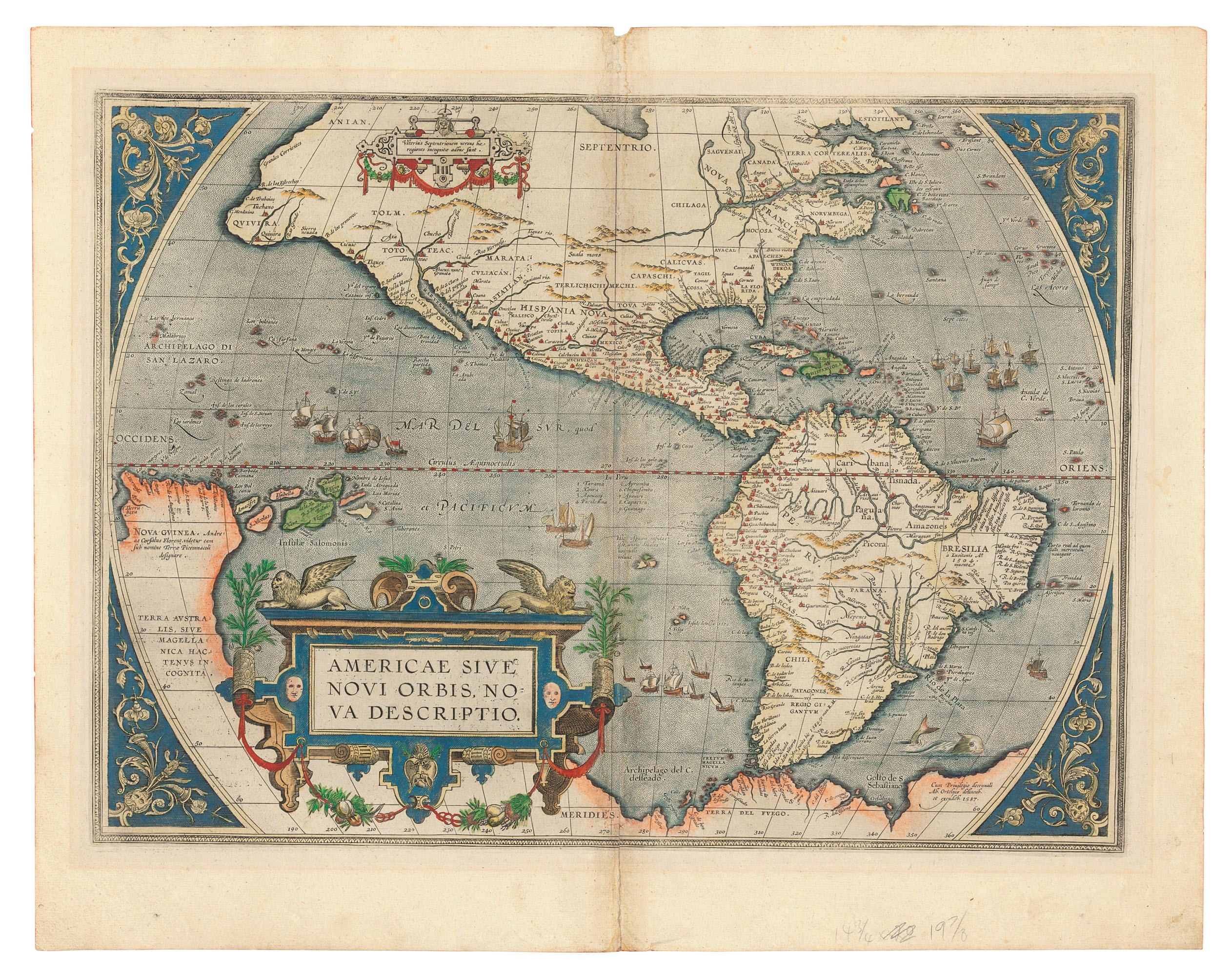
Important edition of Ortelius' map of the Americas, coloured by a contemporary hand. Third edition, from the 1595 Latin edition of the Theatrum orbis terrarum. The map is an improved re-engraving from the earlier editions of the Theatrum, with the bulge removed from the southwest coast of South America, more detailed place names for the west coast of North and South America, and new features on the east coast, including the toponym Wingandeko and an new inlet just above it. These two latter introductions 'both originate from the unsuccessful English attempts to colonise the Outer Banks of present day North Carolina. It has been suggested that the inlet could be the first depiction of Chesapeake Bay on a printed map' (Burden). Burden I, 64; Schwartz and Ehrenberg, pp. 70-71; van den Broecke 11; van der Krogt III map [9000:31C].
Hand-coloured engraved map, 335 x 490mm (434 x 545mm sheet), showing North and South America, the Magellan Strait separating South America from an Antarctic continent named 'Terra del Fuego' which runs westwards into a large landmass named 'Terra Australis' which terminates in a conjoined New Guinea, the whole embellished with numerous ships and a single sea monster, large ornate title cartouche to lower left covering the South Pacific (attached to mount with tape and with some tape remains to margins on verso, lightly creased along centre fold with some associated insignificant losses at head and tail which have been expertly repaired). Latin text on verso with hand-coloured initial.
Americae Sive Novi Orbis. 1595
ORTELIUS, Abraham (1527-1598). Americae Sive Novi Orbis, Nova Descriptio. [Antwerp:] 1587 [but 1595].
Important edition of Ortelius' map of the Americas, coloured by a contemporary hand. Third edition, from the 1595 Latin edition of the Theatrum orbis terrarum. The map is an improved re-engraving from the earlier editions of the Theatrum, with the bulge removed from the southwest coast of South America, more detailed place names for the west coast of North and South America, and new features on the east coast, including the toponym Wingandeko and an new inlet just above it. These two latter introductions 'both originate from the unsuccessful English attempts to colonise the Outer Banks of present day North Carolina. It has been suggested that the inlet could be the first depiction of Chesapeake Bay on a printed map' (Burden). Burden I, 64; Schwartz and Ehrenberg, pp. 70-71; van den Broecke 11; van der Krogt III map [9000:31C].
Hand-coloured engraved map, 335 x 490mm (434 x 545mm sheet), showing North and South America, the Magellan Strait separating South America from an Antarctic continent named 'Terra del Fuego' which runs westwards into a large landmass named 'Terra Australis' which terminates in a conjoined New Guinea, the whole embellished with numerous ships and a single sea monster, large ornate title cartouche to lower left covering the South Pacific (attached to mount with tape and with some tape remains to margins on verso, lightly creased along centre fold with some associated insignificant losses at head and tail which have been expertly repaired). Latin text on verso with hand-coloured initial.
Abraham Ortelius (1527-1598)
Americae Sive Novi Orbis. 1595
ORTELIUS, Abraham (1527-1598). Americae Sive Novi Orbis, Nova Descriptio. [Antwerp:] 1587 [but 1595].
Important edition of Ortelius' map of the Americas, coloured by a contemporary hand. Third edition, from the 1595 Latin edition of the Theatrum orbis terrarum. The map is an improved re-engraving from the earlier editions of the Theatrum, with the bulge removed from the southwest coast of South America, more detailed place names for the west coast of North and South America, and new features on the east coast, including the toponym Wingandeko and an new inlet just above it. These two latter introductions 'both originate from the unsuccessful English attempts to colonise the Outer Banks of present day North Carolina. It has been suggested that the inlet could be the first depiction of Chesapeake Bay on a printed map' (Burden). Burden I, 64; Schwartz and Ehrenberg, pp. 70-71; van den Broecke 11; van der Krogt III map [9000:31C].
Hand-coloured engraved map, 335 x 490mm (434 x 545mm sheet), showing North and South America, the Magellan Strait separating South America from an Antarctic continent named 'Terra del Fuego' which runs westwards into a large landmass named 'Terra Australis' which terminates in a conjoined New Guinea, the whole embellished with numerous ships and a single sea monster, large ornate title cartouche to lower left covering the South Pacific (attached to mount with tape and with some tape remains to margins on verso, lightly creased along centre fold with some associated insignificant losses at head and tail which have been expertly repaired). Latin text on verso with hand-coloured initial.
Americae Sive Novi Orbis. 1595
ORTELIUS, Abraham (1527-1598). Americae Sive Novi Orbis, Nova Descriptio. [Antwerp:] 1587 [but 1595].
Important edition of Ortelius' map of the Americas, coloured by a contemporary hand. Third edition, from the 1595 Latin edition of the Theatrum orbis terrarum. The map is an improved re-engraving from the earlier editions of the Theatrum, with the bulge removed from the southwest coast of South America, more detailed place names for the west coast of North and South America, and new features on the east coast, including the toponym Wingandeko and an new inlet just above it. These two latter introductions 'both originate from the unsuccessful English attempts to colonise the Outer Banks of present day North Carolina. It has been suggested that the inlet could be the first depiction of Chesapeake Bay on a printed map' (Burden). Burden I, 64; Schwartz and Ehrenberg, pp. 70-71; van den Broecke 11; van der Krogt III map [9000:31C].
Hand-coloured engraved map, 335 x 490mm (434 x 545mm sheet), showing North and South America, the Magellan Strait separating South America from an Antarctic continent named 'Terra del Fuego' which runs westwards into a large landmass named 'Terra Australis' which terminates in a conjoined New Guinea, the whole embellished with numerous ships and a single sea monster, large ornate title cartouche to lower left covering the South Pacific (attached to mount with tape and with some tape remains to margins on verso, lightly creased along centre fold with some associated insignificant losses at head and tail which have been expertly repaired). Latin text on verso with hand-coloured initial.
No VAT is payable on the hammer price or buyer’s premium on this lot.